
Rockford Scanner
Official Website

Email: RockfordScanner@gmail.com
Our Opinion; On What Allegedly May Have Happened
Based on the current information that has been provided to us

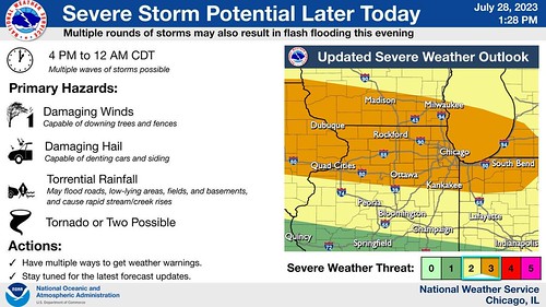
Potential For Severe Weather.
Severe Weather Watch Likely
Severe thunderstorms remain likely this evening and potentially as early as mid afternoon. Primary threat will be in the form of damaging winds and hail, but torrential rainfall may lead to localized flash flooding, especially where multiple rounds of storms train over the same areas. A tornado or two cannot be ruled out. Remain weather aware this afternoon!
After today’s storms clear the area, more seasonable temperatures and lower humidity levels can be expected this weekend. Large waves will lead to dangerous swimming conditions at southern Lake Michigan beaches on Saturday.
This Hazardous Weather Outlook is for portions of North Central
Illinois…Northeast Illinois and Northwest Indiana.
.DAY ONE…This Afternoon and Tonight.
Weather hazards expected…
Significant Thunderstorm Risk…with an associated:
Elevated Damaging Wind Risk…up to 70 mph.
Limited Hail Risk…up to half dollar size.
Limited Tornado Risk.
Elevated Flooding Risk.
Significant Excessive Heat Risk.
Key forecast messages:
* Scattered strong to severe thunderstorms to continue through the
pre-dawn hours.
* Another day of oppressive heat and humidity expected today until
late day storms arrive. No changes made to the ongoing heat
headlines.
* Threat for severe weather and flash flooding late this afternoon
into tonight. Severe weather threat level upgraded to Enhanced
(level 3/5) for northern Illinois with damaging winds as the
primary threat.
Through sunrise:
A busy period of weather to close out the workweek is already well
underway here even before the sun has risen with ongoing scattered
strong to severe overnight convection dancing across northern
Illinois. Based on what we know so far, these storms produced a few
isolated severe wind gusts in interior northern Illinois a little
earlier, and additional instances of damaging winds and small hail
cannot be ruled out through sunrise as a nearby shortwave and the
composite outflow from this activity continues to generate new
convection amidst the presence of over 3000 J/kg of MUCAPE in areas
where the atmosphere hasn’t been convectively overturned to a
significant extent yet.
Friday afternoon heat:
The inability of high-resolution guidance to get a good handle on
our pre-dawn storms lowers confidence in our temperature and heat
index forecast for today, but it appears that the ongoing showers
and storms should be out the area by mid-morning. Assuming that this
does occur and that new convection doesn’t unexpectedly redevelop
later this morning (which is really never a guarantee in these
extremely moist and highly unstable air masses), the combination of
clearing skies and southwesterly winds should allow for temperatures
to warm into the 90s pretty much area-wide heading into this
afternoon. With dew points expected to remain in the 70s to low 80s
throughout the day, heat indices are expected to peak in the 105-110
degree range across most of our CWA (highest across our southwestern
counties where the Excessive Heat Warning is in effect). The lone
exception to this may be portions of far northeastern Illinois,
where heat indices may remain just under the 105 degree Heat
Advisory threshold, so have not made any changes to the going heat
headlines for today with Lake County being the lone county not under
a heat headline at the moment. If the morning convection/cloud cover
hangs around longer than anticipated, or we recover faster than
expected after sunrise once this activity has cleared the area, then
the day shift may need to adjust our heat headlines when our morning
forecast updates are done.
Friday afternoon/evening severe storm and flash flooding potential:
Attention this afternoon and into the evening will then turn to the
potential for another round of severe weather, one that seems likely
to be more impactful than our ongoing pre-dawn storms. Again,
operating under the assumption that new convection doesn’t
unexpectedly fire here during the morning hours, late afternoon/
early evening thermodynamic profiles within the LOT CWA should be
characterized by MLCAPE values that would peak near 3000-4000 J/kg,
steep to very steep low- and mid-level lapse rates, and equilibrium
levels pushing 45000 ft AGL. Kinematic profiles won’t be
exceptional, but as a belt of modestly enhanced 500 mb flow inches
southward, 35-40 kts of effective bulk shear will be realized, which
will be plenty to support a threat of organized severe weather in
the presence of the aforementioned thermodynamic parameters.
Again, with high-resolution guidance out to lunch on the pre-dawn
convection, confidence in the specifics of exactly when the late day
convection will get going and precisely where convective initiation
will occur is low. However, the general expectation is that
convection will light up along a frontal zone and/or residual
outflow from this pre-dawn convection this afternoon as another
shortwave approaches from the northwest. An initial mix of
supercells, multicell clusters, and eventual bowing segments should
carry a threat for damaging winds and large hail before upscale
growth yields one or more eastward/southeastward-propagating MCSs
featuring a predominant threat for damaging winds. The expected
degree of available instability, corresponding DCAPE values around
1500 J/kg, and modeled wind fields depicted in some CAMs suggest
that a corridor or two of significant wind gusts may even occur
somewhere. While the overall synoptic environment is not
particularly favorable to support a heightened tornado threat
(limited 0-1 km and 0-3 km shear/helicity), brief QLCS spin-ups
cannot be ruled out within any west-to-east surging bowing segments,
especially if there are any outflow boundaries lying around for this
mature linear convection to ingest.
In addition to the potential for severe weather, near-record
precipitable water values for our region (2.0-2.3″), deep warm cloud
layer depths, and the aforementioned instability should facilitate
efficient downpours within any deep convection. If any thunderstorm
training occurs, then that may quickly lead to flash flooding
concerns wherever this corridor of training sets up.
All things considered, this has the looks of a classic mid/late
summertime severe weather event for our region, and the SPC
upgrade to a wind-driven Enhanced (level 3/5) Risk in their
latest Convective Outlook appears justified even with the
remaining uncertainties.
DISCUSSION…
Dangerous heat is expected through this afternoon away from the
Illinois shore of Lake Michigan with peak indices generally
between 100 and 110 degrees, and locally up to 115 degrees well
inland.
Thunderstorms are expected to develop along a cold front late
this afternoon through tonight. Some of these thunderstorms are
expected to be severe late this afternoon through this evening,
capable of producing damaging to locally destructive winds and
large hail. A brief tornado or two is also possible. In addition,
some of the storms will produce torrential rainfall which could
lead to flash flooding.

If you have any information:
RockfordScanner@gmail.com
Non-Emergency Outside the City of Rockford
Phone: 815-282-2600
Non-Emergency Inside the City of Rockford
Phone: 815-966-2900
For emergencies, please call 911.
To submit a tip to Rockford PD, download the ROCKFORD PD app
or you can text the RPD at 847411, type in RPD TIP and then your tip.
It’s anonymous!
- Send a text to 847411
- Then type in RPD TIP, then write your tip.
- Hit send.

CLICK HERE TO SUPPORT OUR WORK!
Thank you in advance for your donation!


SUPPORT ROCKFORD SCANNER
Thank you in advance for your donation!


See it, Snap it, Send it
SEE IT: See a scene or something of interest
SNAP IT: Pull our your camera and film
SEND IT: RockfordScanner@Gmail.com

Checkout one of the best
Police scanner on the market!
If you see an error.
Please let us know right away!
We strive for accuracy.
*** A simple anonymous email saying ***
Hey that is not what happened.
But this “IS” what happened…
Email us at
RockfordScanner@gmail.com
Simple communication and transparency,
Would eliminate any misinformation or exaggerations.
Our content is for entertainment purposes only.
Informative entertainment.
- All the information posted is our own personal opinions.
- Our opinions on what allegedly may have possibly have happened.
- Based on the information that was currently provided to us, at the time of posting it.
- We strongly recommend you doing your own research, and forming your own opinion.
- We are protected by the 1st amendment.
- Everyone is innocent, until proven guilty in a court of law.
- We can not guarantee the accuracy of our content.
- Information is very dynamic. You must read and agree to our terms.
- If you do not agree with our terms, please leave now.
- Any corrections, please contact us right away.
RockfordScanner@gmail.com
CLICK HERE TO READ OUR
DISCLAIMER & TERMS