

Rockford Scanner

Email: RockfordScanner@gmail.com
Current information that has been provided to us
UPDATE: TORANDO WATCH HAS BEEN ISSUED:
THE NATIONAL WEATHER SERVICE HAS ISSUED TORNADO WATCH 477 IN
EFFECT UNTIL 10 PM CDT THIS EVENING FOR THE FOLLOWING AREAS
IN ILLINOIS THIS WATCH INCLUDES 15 COUNTIES
IN NORTH CENTRAL ILLINOIS
BOONE DE KALB LA SALLE
LEE OGLE WINNEBAGO
Winnebago-Boone-McHenry-Lake IL-Ogle-Lee-De Kalb-Kane-DuPage-
La Salle-Kendall-Grundy-Kankakee-Livingston-Iroquois-Ford-
Northern Cook-Central Cook-Southern Cook-Northern Will-
Southern Will-Eastern Will-Lake IN-Porter-Newton-Jasper-Benton-
411 PM CDT Wed Jul 12 2023 /511 PM EDT Wed Jul 12 2023/
This Hazardous Weather Outlook is for portions of North Central
Illinois…Northeast Illinois and Northwest Indiana.
.DAY ONE…Tonight.
Weather hazards expected…
Elevated Thunderstorm Risk…with an associated:
Elevated Tornado Risk.
Limited Hail Risk…up to Two Inch Size.
Limited Damaging Wind Risk…up to 70 mph.
Elevated Flooding Risk.
DISCUSSION…
Severe thunderstorms are expected this afternoon and evening
across northern Illinois into northwest Indiana. This includes a
threat of damaging tornadoes. Additional hazards include damaging
wind and hail. Localized areas of flash flooding, especially in
urban areas, are also possible.
.DAYS TWO THROUGH SEVEN…Thursday through Tuesday.
Thursday…
Limited Thunderstorm Risk.
Friday…
Limited Flooding Risk.
Limited Thunderstorm Risk.
Saturday through Tuesday…
Limited Thunderstorm Risk.
.SPOTTER INFORMATION STATEMENT…
Spotters will be needed through this evening.
GENERAL STORM MOTION OF THE DAY:
Moving toward the east southeast at 30 mph.
$$
LMZ740>745-132115-
Winthrop Harbor to Wilmette Harbor IL-
Wilmette Harbor to Northerly Island IL-
Northerly Island to Calumet Harbor IL-
Calumet Harbor IL to Gary IN-Gary to Burns Harbor IN-
Burns Harbor to Michigan City IN-
411 PM CDT Wed Jul 12 2023
This Hazardous Weather Outlook is for portions of the Illinois
nearshore waters of Lake Michigan and the Indiana nearshore
waters of Lake Michigan.
.DAY ONE…Tonight.
Weather hazards expected…
Elevated Thunderstorm Risk…with an associated:
Elevated Waterspout Risk.
Limited Hail Risk…up to Two Inch Size.
Limited Thunderstorm Wind Gust Risk…up to 60 kt.
.DAYS TWO THROUGH SEVEN…Thursday through Tuesday.
Thursday through Monday…
Limited Thunderstorm Risk.

Strong to severe storms are developing in northwest Illinois and moving east south east at approximately 30 mph. There is an increasing risk for damaging tornadoes, hail, and heavy downpours, primarily in the yellow shaded area in the graphic, through 7 PM CDT tonight. Be sure to have multiple ways to receive weather warnings and stay up to date with current forecasts.
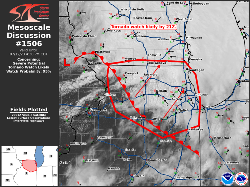
Probability of Watch Issuance…95 percent
SUMMARY…A tornado watch is likely across northern Illinois and
possibly southern Wisconsin by 21Z.
DISCUSSION…The air mass is recovering rapidly across northern
Illinois in the wake of the morning MCS. An EML, advecting eastward
amid 40-50 knots of mid-level flow has cleared out cloud cover and
allowed for surface heating across eastern Iowa and northwest
Illinois. Temperatures in this area have warmed into the low 80s
with dewpoints remaining steady, or even climbing slightly, into the
low 70s. Temperatures remain in the 60s across northern Illinois,
but expect this warm front to lift quickly northeast through the
evening as a result of surface heating north of this front and
strengthening low-level flow in response to the deepening surface
cyclone across eastern Iowa.
Additional heating, combined with cooling temperatures aloft ahead
of the approaching shortwave trough should result in 1500 to 2000
J/kg MLCAPE by this evening across northern and northeast Illinois.
This instability will be co-located with a strong, veering wind
profile (sampled by the 20Z LOT VWP). Expect a similar wind profile
(featuring 200+ m2/s2 0-500m SRH) to remain along the outflow
boundary/composite front through the evening. Supercells are
expected to form along this boundary as ascent increases ahead of a
digging mid-level shortwave trough and within the left-exit region
of the upper-level jet. Southerly winds ahead of the surface low
will provide sufficient low-level streamwise vorticity for a tornado
threat. However, any storms which remain along or slightly
north/east of the boundary, where more backed surface winds will be
present, should ingest much higher SRH and will pose a greater
tornado threat and even the potential for a strong tornado. In
addition, large hail and damaging wind gusts will be possible.
A tornado watch is likely by 4pm to cover this threat.

CLICK HERE TO SUPPORT OUR WORK!
Thank you in advance for your donation!


SUPPORT ROCKFORD SCANNER
Thank you in advance for your donation!


See it, Snap it, Send it
SEE IT: See a scene or something of interest
SNAP IT: Pull our your camera and film
SEND IT: RockfordScanner@Gmail.com

Checkout one of the best
Police scanner on the market!
If you see an error.
Please let us know right away!
We strive for accuracy.
*** A simple anonymous email saying ***
Hey that is not what happened.
But this “IS” what happened…
Email us at
RockfordScanner@gmail.com
Simple communication and transparency,
Would eliminate any misinformation or exaggerations.
Our content is for entertainment purposes only.
Informative entertainment.
All the information posted is our own personal opinions.
Our opinions on what allegedly may have possibly have happened.
Based on the information that was currently provided to us, at the time of posting it.
We strongly recommend you doing your own research, and forming your own opinion.
We are protected by the 1st amendment.
Everyone is innocent, until proven guilty in a court of law.
We can not guarantee the accuracy of our content.
Information is very dynamic. You must read and agree to our terms.
If you do not agree with our terms, please leave now.
If you know of any corrections, please contact us right away.
RockfordScanner@gmail.com
CLICK HERE TO READ OUR
DISCLAIMER & TERMS