

Rockford Scanner
News, Editorials, Events, Paranormal,
Sports, Weather, Letters to the Editor, Reviews, Opinions,
Police Scanner, Advertisements, Humor, Jokes, Satire, Parody,
Whatever we feel like posting about…
We strongly recommend you doing your own research,
And forming your own opinions.


Facts: Simple communication and transparency
WOULD eliminate any misinformation or exaggerations
Fitness Equipment by Power Systems
Our opinion on what allegedly may have happened,
Based on the information that has currently been provided to us.
Any Errors/Corrections, Please Contact Us: RockfordScanner@gmail.com
New video from inside the Apollo Theater, by Gabby Lewellyn
Scroll down for info from the NWS
VIEWER DISCRETION ADVISED

Here is a preliminary summary of the Davis Junction to Belvidere tornado on the evening of Friday March 31, 2023.
This EF-1 tornado tracked 27.7 miles across portions of
Ogle, Winnebago, and Boone counties
Resulting in 1 fatality and 40 injuries in Belvidere
Due to the roof collapse at the Apollo Theatre.
It began near Armour rd near Stillman Valley
And it ended near Orth rd and Capron.
Fast Facts
- Two Gofundme pages have been setup for 2 of the victims.
* https://www.gofundme.com/f/fred-livingston-jr
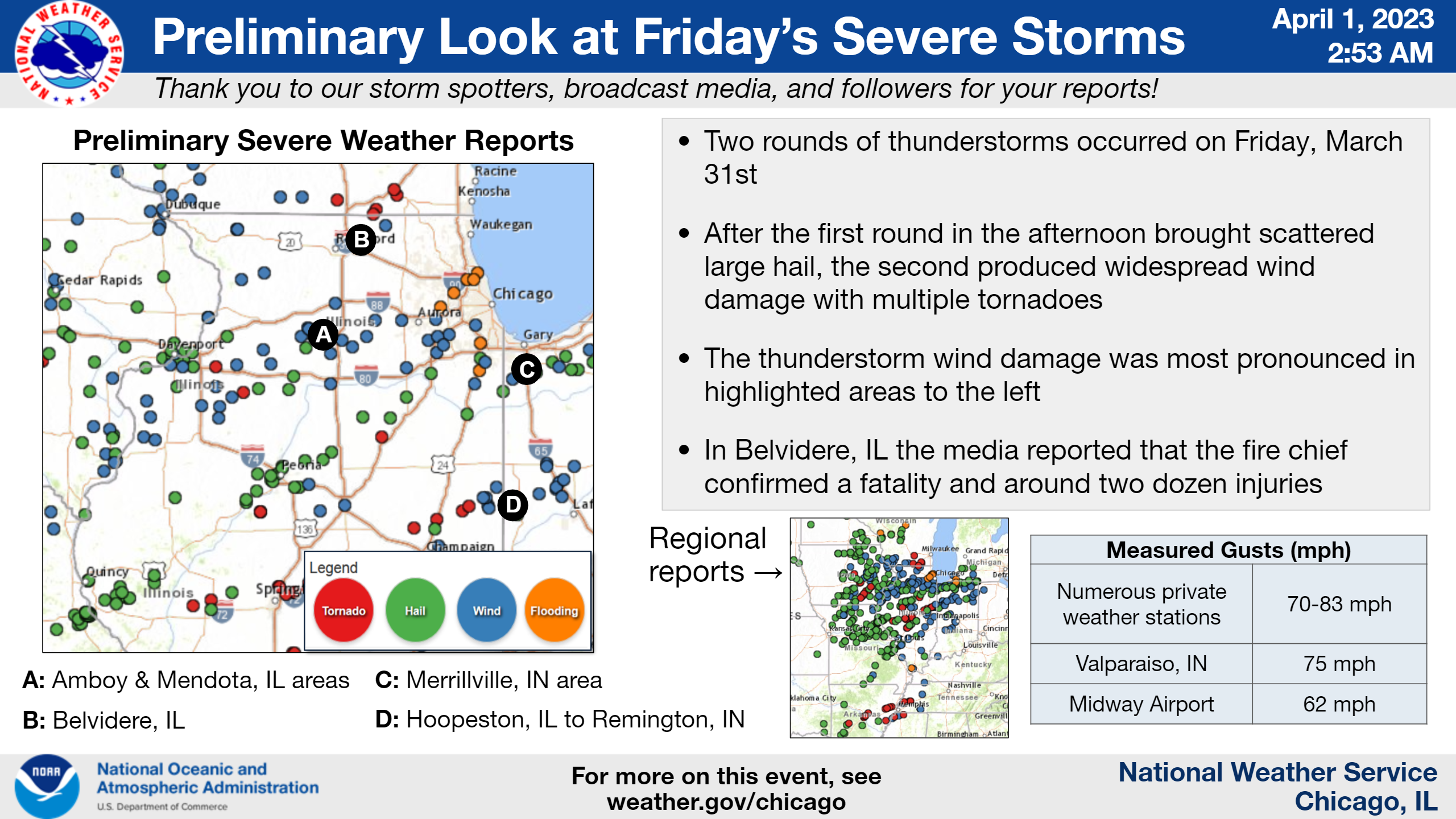
* https://www.gofundme.com/f/financial-relief-for-michelle-il-roof-collapse - Two rounds of severe thunderstorms occurred on Friday, March 31:
one in the afternoon and another, more intense and widespread round during the evening.
- The first round produced mainly scattered instances of large hail across northern Illinois.
- The second round of storms had a history of producing significant severe damage across the eastern half of Iowa through northern and central Illinois.
- There had been a forecast and communicated severe weather risk beginning on Monday for Friday. This risk was increased to a Level 4 of 5 risk, which happens about once every year to two years in northern Illinois and northwest Indiana.
- A Tornado Watch was issued at 2:30 P.M. through 10 PM for the entire area.
- Severe Thunderstorm and Tornado Warnings were issued as the storms moved across the area.
- A Tornado Warning was issued for Boone County 20 minutes before the Belvidere damage had occurred.
- In northern Illinois and northwest Indiana, this produced areas of significant wind damage and multiple tornadoes.
- There were radar indications that there was debris within rotating storms, so we expect to find some tornado damage.
- There were numerous measured wind gusts of 60 to 75 mph, with radar indications of even higher wind speeds in some of the storms.
- Areas of most extensive structural, tree damage, and potential tornadoes include:
- West/southwest of Baileyville in northwest Ogle County
- Near Amboy and Sublette in Lee County
- In and near West Brooklyn in southeast Lee County
- In and near Mendota in LaSalle County
- In Belvidere in Boone County, where media reported that the fire chief confirmed a fatality and near two dozen injuries
- In northern Boone County near Caledonia/Poplar Grove and towards the Wisconsin state line
- In the Harvard area in McHenry County
- In downtown Batavia just west of the Fox River
- In/around Merrillville in Lake County, IN
- In southern Iroquois County, Illinois into Benton and far southern Jasper Counties in Indiana
As of Saturday, April 1, we have confirmed at least two tornadoes in our area of responsibility. These are:
- West/southwest of Baileyville where several farm structures were destroyed. A tornado debris signature was observed from the Davenport/Quad Cities doppler radar.
- Near Caledonia where a trained spotter reported a tornado illuminated by lightning. A tornado debris signature was observed from the Milwaukee doppler radar.
Information will be updated here regarding any additional tornado tracks pending NWS storm surveys and follow-up work with county Emergency Management Agencies.
...NWS Damage Survey for March 31, 2023 Tornado Event...

.Davis Junction to Belvidere...

Rating:                 EF1
Estimated Peak Wind:    100 mph
Path Length /statute/:  27.70 miles
Path Width /maximum/:   900 yards
Fatalities:             1
Injuries:               40

Start Date:             03/31/2023
Start Time:             07:24 PM CDT
Start Location:         2 SE Stillman Valley / Ogle County / IL
Start Lat/Lon:          42.0723 / -89.1497

End Date:               03/31/2023
End Time:               07:49 PM CDT
End Location:           4 S Capron / Boone County / IL
End Lat/Lon:            42.3296 / -88.7382

Survey Summary:
The Davis Junction to Belvidere tornado touched down in the
northeast portion of Ogle county southwest of Davis Junction at
724 PM CDT. The tornado tracked northeast through the village of
Davis Junction where it caused generally EF-0 damage with
isolated EF-1 damage to a single family home on the north side of
town. The tornado continued northeast into southeastern Winnebago
County causing generally EF-0 damage to multiple farms as the
tornado reached its widest extent of about half a mile. The
tornado then continued into Boone County causing damage to farms.
As the tornado neared Belvidere, the width decreased to about a
quarter of a mile but briefly intensified near the central
business district. Peak winds estimated at about 100 mph occurred
at the Apollo Theatre where a portion of the roof collapsed,
causing 1 fatality and 40 injuries. The tornado continued
northeast into rural areas of Boone County causing EF-0 damage
until lifting near Orth Road and Capron Road at about 7:49 PM CDT.

&&

EF Scale: The Enhanced Fujita Scale classifies tornadoes into the
following categories:

EF0...Weak......65 to 85 mph
EF1...Weak......86 to 110 mph
EF2...Strong....111 to 135 mph
EF3...Strong....136 to 165 mph
EF4...Violent...166 to 200 mph
EF5...Violent...>200 mph

NOTE:
The information in this statement is preliminary and subject to
change pending final review of the event and publication in
NWS Storm Data.
After collaboration with local Emergency Management officials and an in-person NWS Damage Survey, an EF-1 tornado impacted Machesney Park yesterday evening.
Information about the path length and width (including a map) will be shared in the coming days.
We are also aware of damage in Rockford and continue to work with local Emergency Management officials on a survey. Additional information about the damage in Rockford will be shared in the next few days.
PRELIMINARY LOCAL STORM REPORT...SUMMARY
NATIONAL WEATHER SERVICE CHICAGO IL
534 AM CDT SAT APR 1 2023
..TIME... ...EVENT... ...CITY LOCATION... ...LAT.LON...
..DATE... ....MAG.... ..COUNTY LOCATION..ST.. ...SOURCE....
..REMARKS..
0342 PM HAIL 2 S STREATOR 41.10N 88.83W
03/31/2023 M1.00 INCH LIVINGSTON IL TRAINED SPOTTER
0403 PM HAIL MAZON 41.24N 88.42W
03/31/2023 M0.88 INCH GRUNDY IL TRAINED SPOTTER
NICKEL SIZE HAIL.
0405 PM HAIL 6 SE RANSOM 41.09N 88.57W
03/31/2023 M0.75 INCH LIVINGSTON IL PUBLIC
REPORT FROM MPING: DIME (0.75 IN.).
0408 PM FUNNEL CLOUD 5 ESE CORNELL 40.96N 88.65W
03/31/2023 LIVINGSTON IL AMATEUR RADIO
1 MILE NORTH OF I-55 ON IL-23. UNSURE
WHETHER THE FUNNEL TOUCHED DOWN.
0413 PM HAIL 1 SW KANKAKEE 41.11N 87.88W
03/31/2023 U1.00 INCH KANKAKEE IL TRAINED SPOTTER
0414 PM HAIL KANKAKEE 41.12N 87.86W
03/31/2023 M0.50 INCH KANKAKEE IL PUBLIC
CORRECTS TIME OF PREVIOUS HAIL REPORT FROM
KANKAKEE. RELAYED VIA SOCIAL MEDIA.
0415 PM HAIL 3 SE CHANNAHON 41.40N 88.19W
03/31/2023 M1.00 INCH WILL IL PUBLIC
REPORT FROM MPING: QUARTER (1.00 IN.).
0423 PM HAIL KANKAKEE 41.12N 87.86W
03/31/2023 M0.50 INCH KANKAKEE IL PUBLIC
RELAYED VIA SOCIAL MEDIA.
0432 PM HAIL 6 SE BEECHER 41.28N 87.53W
03/31/2023 M0.75 INCH KANKAKEE IL PUBLIC
0446 PM HAIL MATTESON 41.51N 87.74W
03/31/2023 E1.00 INCH COOK IL TRAINED SPOTTER
0454 PM HAIL LAKES OF THE FOUR SEASO 41.41N 87.22W
03/31/2023 M1.00 INCH LAKE IN TRAINED SPOTTER
.
0454 PM HAIL LAKES OF THE FOUR SEASO 41.41N 87.22W
03/31/2023 M1.00 INCH LAKE IN TRAINED SPOTTER
0455 PM HAIL 1 SSE VALPARAISO 41.46N 87.05W
03/31/2023 E1.00 INCH PORTER IN PUBLIC
PHOTO SHARED OF HAIL IN VALPARAISO WITH THE
LARGEST HAILSTONES BEING APPROXIMATELY
QUARTER SIZED.
0456 PM HAIL 1 NNW VALPARAISO 41.48N 87.07W
03/31/2023 M1.00 INCH PORTER IN TRAINED SPOTTER
0503 PM HAIL 6 ENE VALPARAISO 41.52N 86.95W
03/31/2023 M0.70 INCH PORTER IN PUBLIC
0536 PM HAIL SUBLETTE 41.64N 89.23W
03/31/2023 M0.88 INCH LEE IL LAW ENFORCEMENT
0549 PM FLOOD 1 NE OAK FOREST 41.61N 87.74W
03/31/2023 COOK IL PUBLIC
1 FT OF STANDING WATER AT THE CICERO AND
159TH ST. UNDERPASS.
0616 PM FLOOD WOOD DALE 41.96N 87.98W
03/31/2023 DUPAGE IL PUBLIC
SOCIAL MEDIA PHOTO SHOWS AT LEAST 1 FOOT OF
STANDING WATER ON RESIDENTIAL STREETS IN
WOOD DALE.
0659 PM TORNADO 6 NW FORRESTON 42.19N 89.65W
03/31/2023 OGLE IL EMERGENCY MNGR
SEVERAL FARM STRUCTURES DESTROYED IN FAR
NORTHWEST OGLE COUNTY. TORNADO DEBRIS
SIGNATURE OBSERVED ON KDVN RADAR.
0705 PM TSTM WND DMG 6 NNE HARVARD 42.49N 88.55W
03/31/2023 MCHENRY IL TRAINED SPOTTER
TREE DAMAGE REPORTED AT ALDEN RD AND STATE
LINE RD.
0706 PM FLOOD WHEATON 41.86N 88.11W
03/31/2023 DUPAGE IL PUBLIC
PHOTO SHOWS 1-2 FT OF STANDING WATER
COVERING RESIDENTIAL STREET AND FRONT YARD.
0706 PM FLOOD WHEATON 41.86N 88.11W
03/31/2023 DUPAGE IL PUBLIC
PHOTO SHOWS 1-2 FT OF STANDING WATER
COVERING RESIDENTIAL STREET AND FRONT YARDS.
0711 PM TSTM WND DMG 1 WNW AMBOY 41.72N 89.34W
03/31/2023 LEE IL EMERGENCY MNGR
GRAIN BIN DAMAGED AT MAPLEHURST FARMS. TIME
ESTIMATED BASED ON RADAR.
0711 PM TSTM WND DMG 2 WNW ROMEOVILLE 41.66N 88.13W
03/31/2023 WILL IL TRAINED SPOTTER
I-55 NEAR WEBER ROAD - SEMI-BLOWN OVER ON
I-55.
0711 PM TSTM WND DMG 5 SW AMBOY 41.66N 89.40W
03/31/2023 LEE IL PUBLIC
DESTORYED BARN PHOTO SHARED BY PUBLIC TO
SOCIAL MEDIA, TIME ESTIMATED ON RADAR.
0713 PM TSTM WND DMG 2 NNW PLAINFIELD 41.63N 88.22W
03/31/2023 WILL IL TRAINED SPOTTER
135TH ST AND RT. 30. SHINGLES BLOWN OFF,
PATIO FURNITURE BLOWN UP OVER THE HOUSE.
0715 PM FLASH FLOOD 1 WSW GOLF 42.05N 87.80W
03/31/2023 COOK IL PUBLIC
NUMEROUS PUBLIC REPORTS OF FLOODED ROADWAYS
IN MORTON GROVE.
0715 PM FLOOD 1 ENE DES PLAINES 42.05N 87.86W
03/31/2023 COOK IL PUBLIC
NUMEROUS PUBLIC REPORTS OF FLOODED ROADWAYS
IN PARK RIDGE AND DES PLAINES.
0715 PM FLOOD 1 ENE DES PLAINES 42.05N 87.86W
03/31/2023 COOK IL PUBLIC
NUMEROUS REPORTS OF FLOODED ROADWAYS IN PARK
RIDGE AND DES PLAINES.
0717 PM TSTM WND DMG 1 W LEMONT 41.67N 88.03W
03/31/2023 COOK IL TRAINED SPOTTER
SEMI BLOWN OVER ON I-355 ON LEMONT BRIDGE
CROSSING OF THE DESPLAINES RIVER.
0718 PM TSTM WND DMG 1 SW MENDOTA 41.54N 89.13W
03/31/2023 LA SALLE IL EMERGENCY MNGR
5 MOBILE HOME TRAILERS WITH THEIR ROOFS
PEELED OFF (TRAILERS ARE STILL STANDING).
HEAVY DUTY 6 INCH GIRDERS/I-BEAMS TOSSED
ONTO ADJACENT PARKING LOT AT FACILITY ACROSS
THE STREET.
0719 PM TSTM WND GST SUBLETTE 41.65N 89.23W
03/31/2023 M74 MPH LEE IL PUBLIC
0721 PM TSTM WND DMG MENDOTA 41.55N 89.12W
03/31/2023 LA SALLE IL EMERGENCY MNGR
SEVERAL TREES AND POWER LINES DOWNED IN
MENDOTA.
0722 PM TSTM WND DMG 5 NE MENDOTA 41.60N 89.06W
03/31/2023 LA SALLE IL TRAINED SPOTTER
TWO SEMIS BLOWN OVER ON I-39 NORTHEAST OF
MENDOTA.
0722 PM TSTM WND DMG 1 NNW LA SALLE 41.34N 89.10W
03/31/2023 LA SALLE IL EMERGENCY MNGR
LARGE TREE (DIAMETER AROUND 2 FEET) SNAPPED
ON MAPLE ROAD IN LA SALLE. TIME ESTIMATED
BASED ON RADAR.
0724 PM TSTM WND DMG 4 SW STEWARD 41.81N 89.08W
03/31/2023 LEE IL PUBLIC
PHOTOS SHARED ON SOCIAL MEDIA OF TWO GRAIN
BINS HEAVILY DAMAGED ALONG WITH 5 LARGE
TREES EITHER WITH THEIR TRUNKS SNAPPED OR
TOPPLED/UPROOTED.
0724 PM TSTM WND DMG WEST BROOKLYN 41.69N 89.15W
03/31/2023 LEE IL PUBLIC
STRUCTURE DAMAGE TO ROOF, TIME ESTIMATED BY
RADAR.
0724 PM FLASH FLOOD 1 E NORTHFIELD 42.10N 87.76W
03/31/2023 COOK IL PUBLIC
TRAFFIC STOPPED ON I-94 AT WINNETKA ROAD
UNDERPASS DUE TO FLOODING. ROAD MAY BE
CLOSED IN THIS AREA.
0725 PM TSTM WND DMG PERU 41.33N 89.13W
03/31/2023 LA SALLE IL EMERGENCY MNGR
POWER POLES DOWNED PLANK ROAD NEAR THE
LASALLE BUREAU COUNTY BORDER.
0725 PM TSTM WND GST AMBOY 41.71N 89.33W
03/31/2023 M67 MPH LEE IL TRAINED SPOTTER
0729 PM TSTM WND DMG 3 WNW SUBLETTE 41.66N 89.28W
03/31/2023 LEE IL TRAINED SPOTTER
SEVERAL TREES DOWN AT A CAMP SITE NEAR TOWER
RD AND LA MOILLE RD NEAR WOODHAVEN LAKES.
0735 PM TSTM WND GST 2 SSW ROCHELLE 41.89N 89.08W
03/31/2023 M59 MPH OGLE IL ASOS
KRPJ ASOS PEAK GUST.
0735 PM TSTM WND DMG EARLVILLE 41.59N 88.92W
03/31/2023 LA SALLE IL TRAINED SPOTTER
SEVERAL TREES DOWN.
0739 PM TSTM WND DMG 2 N MACHESNEY PARK 42.38N 89.03W
03/31/2023 WINNEBAGO IL TRAINED SPOTTER
LARGE TREE DOWNED AND BLOCKING ROADWAY.
POWER LINES ALSO DOWNED.
0739 PM TSTM WND GST 4 SSW PAW PAW 41.63N 89.02W
03/31/2023 M83 MPH LEE IL PUBLIC
NW EARLVILLE PRIVATE WEATHER STATION
MEASURED NORTH OF MERIDIAN.
0741 PM TSTM WND GST 3 N LELAND 41.66N 88.79W
03/31/2023 M75 MPH DE KALB IL PUBLIC
PRIVATE WEATHER STATION NORTH OF LELAND.
0742 PM TSTM WND DMG 1 S ROCKTON 42.44N 89.07W
03/31/2023 WINNEBAGO IL EMERGENCY MNGR
ROOF DAMAGE AND TREES DOWN IN THE BUCKNELL
SUBDIVISION NEAR OLD RIVER ROAD AND NORTH
MAIN.
0744 PM TSTM WND GST 3 E WATERMAN 41.77N 88.71W
03/31/2023 M64 MPH DE KALB IL PUBLIC
PRIVATE WEATHER STATION RECORDED 64 MPH.
0746 PM TORNADO 1 E CALEDONIA 42.37N 88.87W
03/31/2023 BOONE IL TRAINED SPOTTER
TRAINED SPOTTER REPORTED TORNADO ILLUMINATED
BY LIGHTNING IN THE CALEDONIA AND POPLAR
GROVE AREA. TORNADO DEBRIS SIGNATURE
OBSERVED ON KMKX RADAR.
0747 PM TSTM WND GST 1 ENE DEKALB 41.94N 88.73W
03/31/2023 M74 MPH DE KALB IL TRAINED SPOTTER
TREE DAMAGE AND MINOR GARAGE ROOF DAMAGE
ALSO REPORTED.
0748 PM TSTM WND DMG BELVIDERE 42.26N 88.84W
03/31/2023 BOONE IL EMERGENCY MNGR
EM REPORTS ROOF COLLAPSE ON A BUILDING AT
104 NORTH STATE STREET. POSSIBLE TORNADO
DAMAGE.
0750 PM TSTM WND DMG BELVIDERE 42.26N 88.84W
03/31/2023 BOONE IL FIRE DEPT/RESCUE
*** 1 FATAL, 24 INJ ***
CORRECTS PREVIOUS TSTM WND DMG REPORT FROM
BELVIDERE. FIRE DEPARTMENT REPORTED RELAYED
VIA LOCAL NEWS MEDIA OF A ROOF COLLAPSE
DURING AT CONCERT AT THE APOLLO THEATER IN
BELVIDERE. POSSIBLE TORNADO. AT LEAST 1
FATALITY AND 2 DOZEN INJURIES.
0753 PM TSTM WND DMG 4 SSE SUGAR GROVE 41.71N 88.42W
03/31/2023 KENDALL IL PUBLIC
MULTIPLE REPORTS OF DAMAGE, MAINLY TO TREES,
IN THE VICINITY OF DICKSON AND GALENA ROADS.
DAMAGE CONTINUES ENE TOWARDS MONTGOMERY.
0753 PM TSTM WND GST 2 WNW SUGAR GROVE 41.77N 88.47W
03/31/2023 M64 MPH KANE IL PUBLIC
AURORA ASOS MEASURED 64 MPH.
0758 PM TSTM WND DMG 3 WSW NORTH AURORA 41.79N 88.39W
03/31/2023 KANE IL EMERGENCY MNGR
WIRES DOWNED NEAR HERGET MIDDLE SCHOOL IN
AURORA. TIME ESTIMATED FROM RADAR.
0758 PM TSTM WND DMG 3 WSW NORTH AURORA 41.80N 88.38W
03/31/2023 KANE IL TRAINED SPOTTER
SEMI BLOWN OVER ON I-88 NORTHWEST OF AURORA.
0800 PM TSTM WND DMG 4 NNE CAPRON 42.45N 88.70W
03/31/2023 MCHENRY IL PUBLIC
STRONG WINDS CAUSED DAMAGE TO A RESIDENTIAL
CORRUGATED STEEL GARAGE DOOR.
0800 PM TSTM WND DMG HARVARD 42.42N 88.62W
03/31/2023 MCHENRY IL FIRE DEPT/RESCUE
MAIN POWER POLE SNAPPED IN HALF BLOCKING
ROAD IN THE AREA OF 23500 BLOCK OF STREIT
ROAD.
0801 PM TSTM WND DMG HARVARD 42.42N 88.61W
03/31/2023 MCHENRY IL EMERGENCY MNGR
CORRECTS PREVIOUS WIND DAMAGE REPORT FROM
HARVARD. TREE DAMAGE REPORTED IN HARVARD.
TIME ESTIMATED FROM RADAR.
0801 PM TSTM WND DMG 1 SW BATAVIA 41.84N 88.32W
03/31/2023 KANE IL EMERGENCY MNGR
REPORTS OF EXTENSIVE WIND DAMAGE FROM
MAIN/WILSON STREETS SOUTH TOWARDS WALNUT
STREET AND EAST ACROSS THE FOX RIVER. MOST
CONCENTRATED AREA OF DAMAGE ON ELM STREET
WHERE DOZENS OF TREES DOWNED, SOME ON
HOUSES. CHIMNEY BLOWN OVER AND NUMEROUS
POWERLINES DOWN ACROSS ROUTE 31.
0805 PM TSTM WND DMG 1 SE AURORA 41.74N 88.29W
03/31/2023 KANE IL EMERGENCY MNGR
OAK TREE FELL ONTO THE ROOF OF A HOUSE IN
AURORA. TIME ESTIMATED FROM RADAR.
0805 PM TSTM WND DMG 6 NNE HARVARD 42.49N 88.55W
03/31/2023 MCHENRY IL TRAINED SPOTTER
CORRECTS TIME OF PREVIOUS WIND DAMAGE REPORT
FROM 6 NNE HARVARD. TREE DAMAGE REPORTED AT
ALDEN RD AND STATE LINE RD.
0807 PM FLOOD MONEE 41.42N 87.75W
03/31/2023 WILL IL PUBLIC
STREETS AND YARDS WITH FLOODING.
0809 PM TSTM WND GST 1 N NAPERVILLE 41.78N 88.15W
03/31/2023 M64 MPH DUPAGE IL PUBLIC
PRIVATE WEATHER STATION RECORDED.
0810 PM TSTM WND DMG 2 W WOODSTOCK 42.32N 88.49W
03/31/2023 MCHENRY IL EMERGENCY MNGR
TREE DOWNED. TIME ESTIMATED FROM RADAR.
0812 PM TSTM WND DMG 2 NW GREENWOOD 42.41N 88.41W
03/31/2023 MCHENRY IL EMERGENCY MNGR
TREE DOWNED. TIME ESTIMATED FROM RADAR.
0814 PM TSTM WND GST NWS CHICAGO-ROMEOVILLE 41.60N 88.08W
03/31/2023 M63 MPH WILL IL PUBLIC
MEASURED AT WFO CHICAGO-ROMEOVILLE, IL.
0815 PM TSTM WND GST MORRIS AIRPORT 41.44N 88.42W
03/31/2023 M58 MPH GRUNDY IL AWOS
AT KC09 MORRIS AIRPORT AWOS STATION.
0817 PM TSTM WND DMG 2 WSW WELLINGTON 40.53N 87.71W
03/31/2023 IROQUOIS IL PUBLIC
TOOL SHED TOSSED AND TREE DOWN. POTENTIAL
TORNADO DAMAGE. TIME ESTIMATED FROM RADAR.
0817 PM TSTM WND DMG 2 WSW WELLINGTON 40.53N 87.71W
03/31/2023 IROQUOIS IL EMERGENCY MNGR
CORRECTS PREVIOUS TSTM WND DMG REPORT FROM 2
WSW WELLINGTON. TOOL SHED TOSSED AND TREE
DOWN. POTENTIAL TORNADO DAMAGE. TIME
ESTIMATED FROM RADAR.
0817 PM TSTM WND DMG 1 S WELLINGTON 40.53N 87.68W
03/31/2023 IROQUOIS IL EMERGENCY MNGR
WIRES DOWN. POTENTIAL TORNADO DAMAGE.
0820 PM TSTM WND GST 2 SE LEMONT 41.66N 87.98W
03/31/2023 M61 MPH COOK IL EMERGENCY MNGR
MEASURED AT LEMONT EOC.
0820 PM TSTM WND DMG WEST DUNDEE 42.10N 88.28W
03/31/2023 KANE IL TRAINED SPOTTER
APPROXIMATELY 12 INCH DIAMETER TREE TRUNK
UPROOTED. MANY SMALL TO MEDIUM SIZE BRANCHES
ALSO DOWNED IN THE AREA.
0820 PM TSTM WND DMG STOCKLAND 40.61N 87.59W
03/31/2023 IROQUOIS IL EMERGENCY MNGR
WIRES DOWN. POTENTIAL TORNADO DAMAGE.
0822 PM TSTM WND DMG 1 NE MCHENRY 42.35N 88.26W
03/31/2023 MCHENRY IL EMERGENCY MNGR
WIRES DOWNED ON RIVERSIDE DRIVE IN MCHENRY.
TIME ESTIMATED FROM RADAR.
0830 PM TSTM WND GST 3.0 SW MIDWAY AIRPORT 41.74N 87.78W
03/31/2023 M60 MPH COOK IL CO-OP OBSERVER
0838 PM TSTM WND DMG 4 NE OXFORD 40.56N 87.19W
03/31/2023 BENTON IN EMERGENCY MNGR
REPORTS OF NUMEROUS STRUCTURES DAMAGED ALONG
COUNTY ROAD E 330 S FROM NEAR ATKINSON EAST
TO THE COUNTY LINE. CORNER OF 2ND FLOOR AND
NEARLY ENTIRE ROOF OF NEW CONSTRUCTION
DESTROYED. TIME ESTIMATED.
0840 PM TSTM WND GST PEOTONE 41.33N 87.79W
03/31/2023 M61 MPH WILL IL TRAINED SPOTTER
0844 PM MARINE TSTM WIND 3 NE NAVY PIER 41.92N 87.57W
03/31/2023 M74 MPH LMZ741 IL C-MAN STATION
MEASURED AT THE HARRISON-DEVER CRIB.
0846 PM TSTM WND DMG CREST HILL 41.55N 88.14W
03/31/2023 WILL IL EMERGENCY MNGR
WIRES DOWN AT THEODORE AND CEDARWOOD.
0849 PM TSTM WND DMG 2 E REMINGTON 40.77N 87.12W
03/31/2023 JASPER IN TRAINED SPOTTER
REPORTS OF 6 SEMIS FLIPPED AT SOUTHBOUND
EXIT 201 ON I-65. TIME ESTIMATED BASED ON
RADAR.
0850 PM TSTM WND DMG 2 ESE REMINGTON 40.75N 87.12W
03/31/2023 JASPER IN TRAINED SPOTTER
STRUCTURAL DAMAGE REPORTED AT FBI BUILDINGS
INC. TIME ESTIMATED BASED ON RADAR.
0850 PM TSTM WND DMG PARK FOREST 41.48N 87.69W
03/31/2023 COOK IL PUBLIC
11" BRANCH SPLIT OFF OF AN 18" THICK TREE -
LAKEWOOD BOULEVARD.
0853 PM TSTM WND GST 1 NW LOWELL 41.30N 87.44W
03/31/2023 M62 MPH LAKE IN PUBLIC
MEASURED ON PERSONAL WEATHER STATION.
0853 PM TSTM WND DMG 2 W MERRILLVILLE 41.47N 87.36W
03/31/2023 LAKE IN PUBLIC
PHOTO OF 5 POWER POLES EITHER SNAPPED OR
LEANING DUE TO WIND.
0854 PM TSTM WND GST CEDAR LAKE 41.36N 87.44W
03/31/2023 E60 MPH LAKE IN TRAINED SPOTTER
PENNY SIZE HAIL ALSO.
0856 PM TSTM WND DMG CROWN POINT 41.42N 87.36W
03/31/2023 LAKE IN EMERGENCY MNGR
SEVERAL INSTANCES OF TREE DAMAGE REPORTED IN
CROWN POINT. FENCES ALSO BLOWN DOWN.
0901 PM TSTM WND GST CROWN POINT 41.42N 87.37W
03/31/2023 E70 MPH LAKE IN TRAINED SPOTTER
129TH AND DELAWARE SUSTAINED WINDS 50-55 MPH
E 65-70 GUSTS.
0907 PM TSTM WND DMG 1 NW MERRILLVILLE 41.48N 87.34W
03/31/2023 LAKE IN PUBLIC
76TH AND JACKSON ST AREA. 6-7 HOMES WITH
ROOFS PEELED OFF OVER GARAGES. DEBRIS
SCATTERED AND WRAPPED AROUND TREES AND
POLES, AND TREES DOWN. POTENTIAL TORNADO
DAMAGE.
0910 PM TSTM WND DMG 2 NE VALPARAISO 41.49N 87.04W
03/31/2023 PORTER IN TRAINED SPOTTER
SEVERAL TREES AND POWER LINES DOWNED ACROSS
THE NORTH SIDE OF VALPARAISO.
0911 PM TSTM WND GST VALPARAISO AIRPORT 41.45N 87.01W
03/31/2023 M74 MPH PORTER IN ASOS
65 KT GUST AT KVPZ.
0918 PM MARINE TSTM WIND 4 NE BEVERLY SHORES 41.73N 86.93W
03/31/2023 M63 MPH LMZ745 IN C-MAN STATION
MEASURED AT MCYI3.
0919 PM TSTM WND DMG 3 SSW WHEATFIELD 41.16N 87.08W
03/31/2023 JASPER IN 911 CALL CENTER
TREE DOWNED ONTO ROAD. TIME ESTIMATED FROM
RADAR.
0920 PM TSTM WND DMG 2 ENE FAIR OAKS 41.09N 87.23W
03/31/2023 JASPER IN TRAINED SPOTTER
TREES DOWNED EAST-NORTHEAST OF FAIR OAKS.
TIME ESTIMATED FROM RADAR.
0922 PM TSTM WND GST DEMOTTE 41.19N 87.20W
03/31/2023 M78 MPH JASPER IN TRAINED SPOTTER
POWER POLES ALSO DOWNED IN THE DEMOTTE AREA.
As much as we hate asking for donations.
Sadly, it does cost money to run RS.
Dedicated server, Domain, Maintenance, Time, etc…
Every penny helps!
Donate via debit or credit card:
CLICK HERE
Thank you in advance for your donation!
Officials have not yet released any information:
- To confirm anything (Nothing is confirmed),
- On the incident (What happened?),
- Possible alleged suspects, (Who may be involved?),
- If there is a possible threat to the community (Community in danger?),
- Who to possibly be on the lookout for, (Who to be on the lookout for?),
- If they do release information, we will update this.
If there are no updates, officials have not released any information that we are aware of.

Rockford Scanner
See it, Snap it, Send it
- SEE IT: See a scene or something of interest
- SNAP IT: Pull our your camera and film
- SEND IT: RockfordScanner@Gmail.com
Examples of
Rockford Scanner Fan Submissions


CLICK HERE TO DONATE
Thank you in advance for your donation!

Visit our sponsors:
CLICK HERE
Checkout one of the best
Police scanner on the market!
 Our personal opinions on various topics.
Rockford Scanner
PARANORMAL FILES!

Disclaimer:
- Our content is for entertainment purposes only.
- Informative entertainment.
- All the information posted is our own personal opinions.
- Our opinions on what allegedly may have possibly have happened.
Based on the information that was currently provided to us, at the time of posting it. - We strongly recommend you doing your own research, and forming your own opinion.
- We are protected by the 1st amendment.
- Everyone is innocent, until proven guilty in a court of law.
- We can not guarantee the accuracy of our content.
Information is very dynamic and may change. - If you know of any corrections, please contact us right away.
RockfordScanner@gmail.com - You must read and agree to our terms.
If you do not agree with our terms, please leave now.

Our information is for entertainment purposes only. Because of this, We can not guarantee the accuracy of our information. If you know of any errors, please contact us at RockfordScanner@gmail.com and please provide us with the proof of the correction. We strive for accuracy. But, the information is always dynamic and changes often with our type of content. Because of this, We do apologize ahead of time if there are any errors. So, Please let us know of any updates or errors! We are protected under the first amendment.
Disclaimer and Terms: CLICK HERE